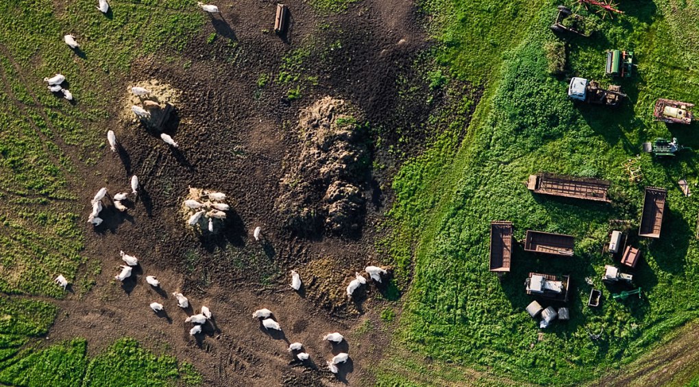
Livestock control refers to the monitoring of stock in terms of positioning and health. Stock control methods vary with the stock sizes, but should be capable of supplying information on the position of the stock and the conditions they are in.
Tracking and inspecting livestock on large agricultural grounds can be a challenging task. Although GPS tracking enables the controller to find the stock easily, the controller still needs to go to the animal to inspect it
A novel way of monitoring livestock is to employ unmanned aerial systems (UAS). The advantage of these systems is that they can cover large areas, provide both GPS location as well as visual information and produce a low noise footprint, which does not scare the animals. UAS can be equipped with multiple camera types or sensors to provide accurate and complete information, thereby lowering stock control time and costs, including collecting data from active transponders embedded in livestock.
Livestock can be controlled and monitored by using unmanned aircraft systems (UAS). An aircraft system with thermal cameras enables one to locate the positioning of livestock. It can also retrieve additional information of the livestock.
The use of RPAS or DRONES allows the surveillance of great spaces from a privileged perspective, even during night hours, and compares their evolution throughout time.
In addition, they are a much more ecological option, as drones don´t generate any kind of pollutants. And all the above at a much lower cost than traditional methods.
Farmers in New Zealand – demonstrated how a quadcopter could herd livestock around vast farms.
Farmers typically require systems to be pre-programming the UAV system for flight using the ground station software as to demand the flight path be contained within their property line. When doing this, each cattle check can be a part of a routine that consists of auto launching the plane for flight, and monitoring the live video feed on screen. Since all video is recorded by the UAV’s ground station software, there is no special need to worry when cattle quickly pass the point of view.
Florescent spray paint that is unique to each cattle head will make your job of auditing your livestock easy.
‘As The Crow Flies…’
Fly straight to your destination with UAVs (Drones).
Anti-Poaching
Poaching entails the illegal hunting, capturing or killing of non-domestic animals. Acts of poaching encompass failure to comply with the Endangered Species Act, hunting without a licence, hunting with illegal methods or hunting at illegal locations.
Anti-poaching measures include patrolling National Parks and habitats to protect the animals, discouraging poaching by removing horns preventively and tracking poachers. Since poaching is generally related to large habitats and parks, close surveillance and monitoring of parks is difficult. Aerial surveillance with helicopters can improve protection measures substantially. However, due to the high costs of helicopters, it is rarely a viable option.
An efficient solution to this problem is employing unmanned aircraft systems (UAS) to perform aerial surveillance. UAS can be equipped with cameras, thermal sensors and sniffers to detect poachers and hazardous gasses. The advantages of UAS’ are: is that they can cover large areas; yet cost only a fraction of helicopters; can be kept and carried on site; and have a very low noise footprint which don’t disturb the animals or alert the poachers.
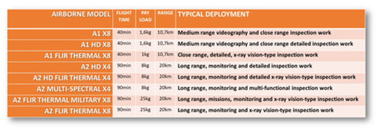
GIDI DRONE provides the modern farmer with a complete airborne UAV platform, that enables remote sensing and record geo-referenced data types that include:
UAV Platforms:
We recommend A2-THERMAL systems for wild life detection and counting. Everything you require comes packed into your kit for ‘out of box use’. Please inquire about onsite training when deciding to go with this system.


